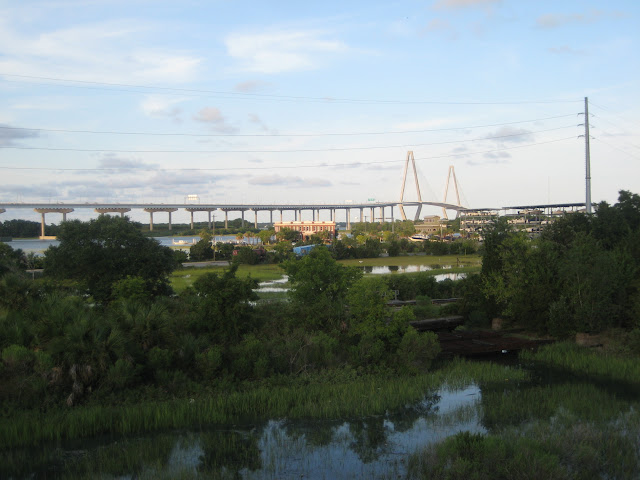
Perhaps no architectural feature of Charleston is more prominent than the Arthur Ravenel Jr Bridge, which spans between downtown and Mount Pleasant and serves as the track for the city’s famous Cooper River Bridge Run, which hosts 50,000 people annually.
Today, the new bridge has a walking path, which allows locals and tourists to trek the 6 miles round trip for the best views of the city. It’s visible from nearly every corner of the city. It’s even been featured in music videos, movies, and television shows like Outer Banks!
This post contains affiliate links.
The History of the Ravenel Bridge

The first bridge was built across the Cooper River in 1929, connecting downtown Charleston to Mount Pleasant. It was named the John P. Grace Memorial Bridge in the cantilevered style but was often referred to simply as the “Cooper River Bridge.
As traffic increased, the bridge had to be widened and in 1966, a twin bridge was built, called the Silas N. Pearman Bridge. But it was also only a temporary solution. A much larger bridge would be needed to handle the many commuters passing between the two sides.
In 2005, the Arthur Ravenel Jr. Bridge was constructed, named for the former congressman that helped to raise funds for the project. Its namesake ran for office with the claim that he would improve roadways and work began in 2001.
The cable-stayed bridge has a pedestrian and cyclist lane named for a local man hit by a car on his bike. The diamond-shaped towers are nearly 600 feet tall and are lit up at night, similar to the Sidney Lanier Bridge in Brunswick and the Talmadge Bridge in Savannah. It was also built to withstand earthquakes and hurricane-force winds with plenty of space for shipping containers to pass underneath.
The prior bridges were demolished over two years starting in 2005 and one small piece still exists on the Charleston side. Some of the metal from the old bridges was dropped into the ocean to create an artificial reef.
Tips for Walking the Ravenel Bridge

If you’re walking the Ravenel bridge on your own, you can park on either end, either downtown Charleston or Mount Pleasant. The Mount Pleasant side has paid parking at Waterfront Park. On the downtown side, there is free parking off of East Bay Street.
The downtown stretch starts with a long walk over the marsh before you even reach the main part of the bridge. Be sure to look at Drum Island underneath, where deer and other animals live. You can either go the full length and take the bus back, go halfway before returning to your car or go both ways. In either case, be sure to yield to bicyclists and stay in your lane.


There are no public restrooms on the downtown side, but there are a water fountain and restrooms on the Mount Pleasant side. I recommend bringing a bottle of water for your walk and starting around dusk to watch the sunset over the Ashley and Cooper rivers. Or pick up a sandwich from nearby East Bay Deli to enjoy when you’re done.
What to See on the Mount Pleasant Side

If you’re walking from downtown to Mount Pleasant, give yourself time to explore before turning back around. The bridge ends around Patriot’s Point, a large area with athletic fields, a golf course, and museums. The USS Yorktown is a restored aircraft carrier used in the Korean and Vietnam wars. There’s also the Medal of Honor Museum.
The Mount Pleasant Memorial Waterfront Park is a nice place to relax with a Revolutionary War Memorial, a playground, a pier, and the River Watch Cafe & Gift Shop. This area also has public restrooms and is a good place to catch a rideshare back downtown.
Have you ever walked across Charleston’s Ravenel Bridge?
PIN IT


Looking for a place to stay nearby? The Charleston Harbor Resort is right off the Mount Pleasant side of the bridge (read our review here) and the Holiday Inn Charleston Downtown is a short drive from the downtown side.

Leave a Reply